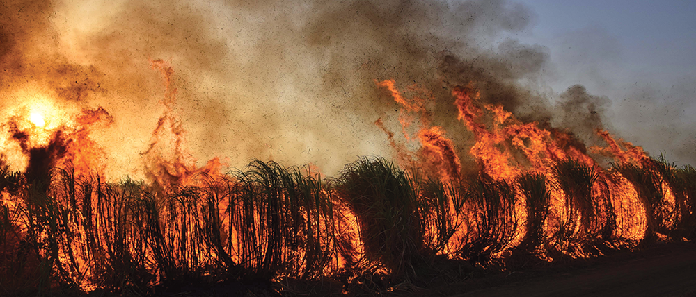


The frequency, severity, and geographic occurrence of wildfires have increased significantly in recent years, fueled by climate change, human activities, and evolving land-use patterns. Their rapid spread poses substantial risks across various sectors and regions around the globe, according to the new Emerging Risk Trend Talk report1 from Allianz Commercial.
As the devastating Los Angeles wildfires in January 2025 showed, the western US, along with western Canada, southern and eastern Australia, and southern Europe, are the geographical zones most exposed to wildfires. However, such fires are also now occurring in locations not previously regarded as a significant risk, including forests in northern regions of Canada, Scandinavia, and Russia. South Korea suffered the deadliest wildfire outbreak in its history during March and April 2025.
Wildfire seasons are starting earlier and lasting longer, which impacts the ability to share firefighting resources within regions. Catastrophic wildfires are becoming larger and more frequent. The impacts of the worst wildfires in the last decade in terms of property damage and fatalities have been significantly greater than for at least 50 to 100 years in some regions.
Climate change is elevating risks by increasing fuel loads, drying out fuels, strengthening winds, boosting lightning activity, and promoting the spread of invasive, flammable species. The 10 warmest years since 1850 have all occurred in the past decade (2015-2024), with 2024 being the hottest on record.
In addition to climate change, wildfire exposures are being intensified by changing land use, particularly in the ‘wildland urban interface’ (WUI) locations, where human development is expanding into areas of wildland vegetation prone to fires. The number of people and property exposed to wildfires is on the rise. This exposure coincides with increased lengths of electricity lines and roadways, both of which are key ignition sources.
Global insured losses from wildfires increased from US$8,7 bn in the 2000s to $56,3 bn in the 2010s2, becoming more than six times more expensive. Any sector can be impacted by a wildfire, but utilities and energy, real estate and construction, and agriculture and transportation are among the sectors which face the most significant exposures to damage and business interruption. Regulatory challenges and litigation related to wildfire liabilities are also on the rise, necessitating the need for robust risk management strategies, the report notes.
Strategies for mitigation
Strategies include creating defensible spaces, managing vegetation and using non-combustible building materials. Fire suppression and protection strategies are also evolving, and companies need to keep up with them. Developing and implementing an effective wildfire preparedness and business continuity program, and regularly reviewing and updating it, is recommended.
There are also a range of increasingly sophisticated technical tools and innovations that can be used to model and mitigate fire risk, the report notes. Examples include seasonal forecasting, drone surveys, geographical information system (GIS) mapping, thermal imaging, vegetation management systems and artificial intelligence cameras.
“Businesses should identify the risk for their operations to trigger wildfires or be impacted by wildfires started by human or natural causes, assess the potential impacts and develop well-documented wildfire management plans appropriate to their operations,” says Michael Bruch, global head of Risk Advisory Services at Allianz Commercial.
Ultimately, wildfire mitigation requires a multifaceted approach, including individual companies’ compliance with all relevant laws and regulations concerning fire safety. More broadly, preparing for wildfire will require efforts to mitigate greenhouse gas emissions, adapting to changing environmental conditions, and implementing effective wildfire management strategies. This might involve a combination of government policies to reduce carbon emissions, land use planning to minimise exposure to wildfire risk, and investments in those technologies that enhance fire detection, prediction, and suppression.
Mitigating wildfires is a complex and pressing issue that requires coordinated action at local, national, and global levels to minimise risks and build resilience in the face of a changing climate, the report concludes.
Allianz Commercial has launched its new Climate Adaptation and Resilience Services (CAReS) tool to help companies better assess and manage the climate risks facing their businesses. The web platform includes a Fire Weather Index, which will help companies prioritise their wildfire resilience investments.
Download the report ARC-Emerging-Risk-Trend-Wildfires at https://tinyurl.com/rde5kxrc
[1] https://tinyurl.com/rde5kxrc
[2] Swiss Re, In 5 charts: natural catastrophes in a changing climate, March 30, 2021
Innovations in modelling and mitigating wildfire risk
There is a range of increasingly sophisticated technical tools and innovations that can be used to model and mitigate fire risk, including the following.
Wildfire risk modelling: Wildfire agencies, research institutions, reinsurers and some electrical utilities have been developing new tools and models to predict the likelihood and consequences of wildfires, as well as early detection to enable prompt suppression. The level of precision with some can be down to the scale of an individual power pole.
Seasonal forecasting: Wildfire risk forecasts are continually being developed and improved, although they are highly complex and contain inherent uncertainties. Electrical utilities increasingly use them to assess and manage wildfire risks on a year-to-year basis.
GIS (geographical information system) mapping: Utilities are increasingly using GIS to map their assets with an overlay of wildfire risk mapping from government agencies to guide asset inspection and maintenance, including vegetation. The best vegetation management contractors are using their clients’ GIS data and mapping each tree, requiring trimming or removal.
Field data management tools: Some utilities and vegetation management contractors are using electronic tablets in the field to report and update progress in vegetation management, seek approval from clients to address urgent issues, report hazards and incidents, and undertake audits, with real-time automated reporting to stakeholders.
LiDAR surveys: There is growing use of LiDAR (light detection and ranging) surveys using drones, helicopters or foot patrols to map vegetation encroachments and the condition of overhead electricity and telecommunications lines. However, these are not foolproof and field crew observations are required to verify findings.
Thermal imaging: This can be used to identify potential abnormalities before failure in vulnerable transmission and distribution lines or equipment.
Vegetation management systems: Improvements in these systems include linking vegetation survey tools to utility assets mapping via GIS, to the scale of individual power poles and even individual trees, overlaid with best-in-class wildfire risk mapping; real-time field reporting on field surveys and vegetation removal works, enabling immediate approval to address new finds; and the development of tools to estimate likely vegetation growth rates, to fine-tune vegetation removal.
Rapid earth current limiters (fast trip devices): Operators in the US and Australia have been installing these devices, or similar devices such as fault current limiters or current limiter circuit breakers, on power lines in areas of high risk. The devices limit or stop the flow of electricity in the event of damage to the electricity line or equipment, reducing the risk of wildfire.
Conductor spacers/spreaders: These prevent powerlines from clashing in high winds.
System hardening works: Electrical and telecommunications utilities in the US and Australia have invested significant sums in system hardening – physical works aimed at reducing the likelihood of their networks triggering a wildfire, including upgrading electricity poles and wires and undergrounding power lines.
De-energising powerlines: This measure is sometimes implemented in times of high risk in certain jurisdictions, including California and Australia. It presents a trade-off between the harm caused by customers having no power and the risks associated with wildfires.
AI cameras: Artificial intelligence cameras on poles in high-risk areas can assist in early fire detection and map its location.
Source: Wildfires Emerging Risk Trend Talk 4, from Allianz Commercial.


© Technews Publishing (Pty) Ltd. | All Rights Reserved.
 printer friendly version