ArcGIS Schematics launched
February 2003

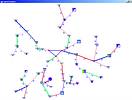
ArcGIS Schematics is a software solution integrated with ESRI geographic information system (GIS) software, allowing network geographic and schematic representations to be visualised and controlled in the same environment. ArcGIS Schematics delivers tools that allow one to automatically generate a graphic representation of a network using its associated database information. It is also a high-end development platform that one can use to rapidly build a variety of custom graphic applications for a network information system. With its advanced functionalities, network graphs and diagrams can be produced on the fly.
ArcGIS Schematics allows one to generate views and analyse networks in geographical, schematic and geoschematic layouts. ArcGIS Schematics is a Windows-based solution that meets the utility industry's need for schematically viewing and manipulating network data.
Powered by a set of configuration files and its data-driven graphics philosophy, ArcGIS Schematics is able to generate schematics from the current state of the GIS network data. This means that ArcGIS Schematics offers a high degree of flexibility and is not limited by the evolution of the data model and by changing database locations.
Included with the ArcGIS Schematics product is ArcGIS Schematics Designer, a graphical user interface (GUI) based design tool that supports configuration and customisation of ArcGIS Schematics; ArcGIS Schematics Designer allows workspace parameters file building.
Also included with ArcGIS Schematics is a set of standard schematic layout algorithms ready to use with network data. ArcGIS Schematics can be customised to support user-specific layout algorithms.
For more information contact GIMS on 011 695 0400.
Others who read this also read these articles
An intelligent, integrated approach
MapIT has crafted a Licensed Partner programme based on the common requirement for highly accurate mapping data[ October 2004 ]
Picture it ...
MarketScope can calculate virtually any demographic scenario for your marketplace, taking into account a variety of factors, including your customer profiles, census information, competitor analysis data and any other set of business-related statistics you wish to evaluate, and visually display the results, arriving at an answer within 30 seconds[ August 2004 ]
Mondi develops advanced GIS business system
Mondi Forests has a truly integrated GIS business system that not only takes care of daily operational requirements, but also facilitates the use of GIS decision-making technology[ June 2003 ]
Implementation of a GIS system in local government
The most cost effective and user friendly way of implementing the MIS system and making it accessible to all authorised officials and Councillors throughout the Municipality was to build a Web application using Bentley Publisher[ April 2003 ]
GIS technology saluted for social and economic contributions
GIS is a powerful analytical tool that integrates spatial (or location) data with associated information, presenting the result in an easy-to-understand, map-based format[ February 2003 ]
Building a locations-based service
Before we can start any project, we need to know and understand what the system is going to be used for[ August 2002 ]
Sustainable fisheries and marine conservation in Kenya
A Microsoft Access database is being developed to manage the data[ August 2002 ]
Calling the competitive shots
“The solution has given us a competitive differentiator which has proved to be a very impressive revenue generator.”[ June 2002 ]
Others who read this also read these news items
Hikers, bikers and urban street pioneers
[ December 2005 ]
Image compression provides post-Katrina aerials within days
[ December 2005 ]
Navigation - the tip of the GIS iceberg
[ October 2005 ]
Fun and affordable in-car navigation
[ October 2005 ]
Cycling on the edge
[ October 2005 ]
Routing made easy
[ August 2005 ]
MapIT expands into West Africa
[ August 2005 ]
Incredible Connection powers navigation tools
[ August 2005 ]
Others who read this also read these regulars
ArcIMS 9.1 Route Server - routing and geocoding
[ October 2005 ]
Enterprise GIS with ArcGIS 9: a comprehensive GIS platform
[ October 2004 ]
GIS in Africa
[ August 2003 ]
Complete logistics and routing solution
[ August 2002 ]
ESRI offers highly integrated GIS solutions
[ April 2002 ]
GIS - the tool to help manage change in the 21st century
[ April/May 2000 ]
GIS software that sets a new standard
[ April/May 2000 ]
Search Site
Subscribe
Previous Issues
Other Technews Publications
Other Technews Buyers Guides
 |  | Copyright c1995-2009 Technews Publishing (Pty) Ltd.. All rights reserved. |